 |
Super Hurricane
Katrina |
|
|
|
Super Hurricane
Katrina |
|
Birth of a Monster
TROPICAL DEPRESSION TWELVE ADVISORY
NUMBER 1...CORRECTED
NWS TPC/NATIONAL HURRICANE CENTER MIAMI FL
5 PM EDT TUE AUG 23 2005
CORRECTED WARNING SECTION
...TWELFTH DEPRESSION OF THE SEASON FORMS OVER THE BAHAMAS...
...TROPICAL STORM WARNINGS ISSUED...
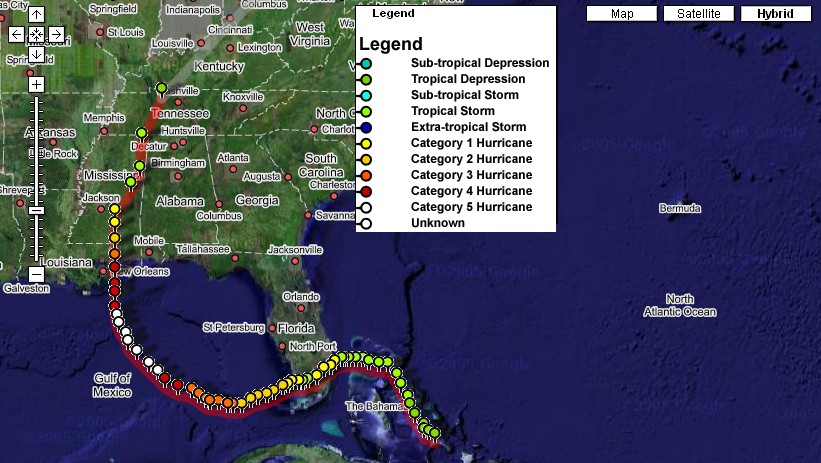
The preamble to Katrina. Advisory #1. Tropical Depression (TD) 12. Little did most people know that TD 12 would grow into the most destructive storm ever to strike the U.S. mainland causing perhaps the worst natural disaster ever in the United States. The center of Tropical Depression 12 was located 175 miles southeast of Nassau, Bahamas with sustained winds of 35 mph and a minimum central pressure of 1007 mb or 29.74" of mercury. Forecasts were already calling for intensification with indications of a heavy rainfall event over south Florida.
By 11AM the next morning of August 24, Katrina had been named as a tropical storm located 50 miles east-southeast of Nassau moving to the north-northwest at 8 mph. Forecast were calling for intensification with a gradual turn to the the northwest over the next 12-24 hours. Forecasts continued to indicate a heavy rainfall event.
The 11PM advisory indicated Katrina had begun to strengthen with winds of 50 mph. Hurricane warnings were issued for southeastern Florida and Lake Okeechobee with the anticipation that Katrina would reach hurricane status prior to landfall. Katrina did not disappoint. In fact, she was beginning an intensification cycle just prior to landfall. Intensification of a tropical system prior to landfall has proven to be more destructive than one that is stable or weakening. Hurricane Andrew was just an example.
Katrina continued to organize and gain strength during the day on August 25 and attained hurricane status by 5PM with 75 mph winds. The storm was located 15 miles east-northeast of Ft. Lauderdale, Florida moving to the west at 6 mph. The slow movement of the storm not only provided the mechanism for heavy rainfall but prolonged hurricane force winds over areas near landfall. Katrina made landfall between 5PM and 7PM between Hallandale Beach and North Miami Beach with winds of 80 mph with higher gusts. Port Everglades reported a gust of 92 mph. South Florida sustained significant wind damage as Katrina passed over the area.
While over extreme south Florida, Katrina began to weaken. In fact she weakened to tropical storm status with 70 mph winds 60 miles northeast of Key West as of the 1AM EDT advisory. Interacting with a strong high pressure to the north, the storm began a southwestern motion at 8 mph. The stubborn high pressure proved to be a thorn-in-the-side of most computer models. They did not accurately predict the continued westward motion. Instead they indicated a landfall in the Florida panhandle somewhere near Apalachicola.
Katrina emerged back over the warm waters of the Gulf of Mexico as of the 3AM EDT advisory some 60 miles north-northeast of Key West, Florida as she continued to move west-southwest at 11 mph - still under the influence of the strong high to the north. Shortly after emerging back over the gulf, Katrina quickly regained hurricane status 50 miles north-northeast of Key West with 75 mph winds. Models were beginning to paint an ominous picture, however.
At 11PM on August 26, Katrina begins her model predicted intensification process - a process that would make history. Winds are now at 105 mph making Katrina a category 2 storm on the Saffir-Simpson hurricane scale. In addition, the storm continues to stubbornly move to the west-southwest at 8 mph over the extremely warm gulf waters. Models continued to indicate a northward turn and extreme intensification.
By morning, Katrina reaches major hurricane category 3 status with 115 mph winds located 435 miles southeast of the mouth of the Mississippi River. The storm had reached the southern periphery of the dominating high pressure system and was now moving west at 7 mph. At 10AM on August 27 a hurricane watch was issued for the Louisiana coast from Morgan City to the mouth of the Pearl River (LA/MS border). Forecast models were now painting a very ominous picture calling for a landfall over southeast Louisiana in 48-60 hours and the storm may reach category 5 status at landfall.
Katrina maintains her strength at 115 mph over the course of the day Saturday, August 27, continuing west at 7 mph. However by 7PM the storm begins a west-northwest turn. The Tropical Prediction Center issues hurricane warnings at 10PM from Morgan City, Louisiana to the Alabama/Florida border. Katrina was now located 335 miles south-southeast of the mouth of the Mississippi River.
Shortly after midnight, Sunday, August 28, Katrina transforms into a monster. The pressure begins to rapidly drop and winds increase to category 4 range at 145 mph. The 5AM advisory emphasized that Katrina could possibly reach category 5 status and that she was a large storm with a large wind field. Forecasts called for a landfall just east of New Orleans over southeast Louisiana.
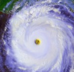
Two hours later at 7AM, Katrina's pressure continued to drop and winds reached 160 mph - a category 5 storm. Forecasts continued to show Katrina making landfall as either a category 4 or 5 storm. The pressure had dropped to 908mb/26.81". The storm was moving to the west-northwest at 12 mph.
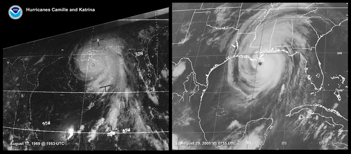
To add insult to injury, the storm's pressure continued to drop through the morning hours. At 10AM the barometer stood at 907mb/26.78" with winds howling at an incredible 175 mph. She was now 225 miles south-southeast of the mouth of the Mississippi River. Katrina's pressure finally bottomed out at 4PM reading 902mb/26.64". The reading was the fourth lowest pressure ever recorded in an Atlantic hurricane behind Gilbert (1988), the Labor Day Hurricane of 1935, and Allen (1980). Katrina's pressure was now lower than that of Hurricane Camille in 1969.
Katrina had completed her intensification process and as characterized by intense hurricanes had begun a weakening cycle due to eyewall replacement. The 7PM advisory had the winds down to 160 mph with a pressure of 904mb/26.69", still a category 5 storm. Katrina had now made the jog to the north and was moving to the north-northwest at 11 mph some 130 miles south of the mouth of the Mississippi River.
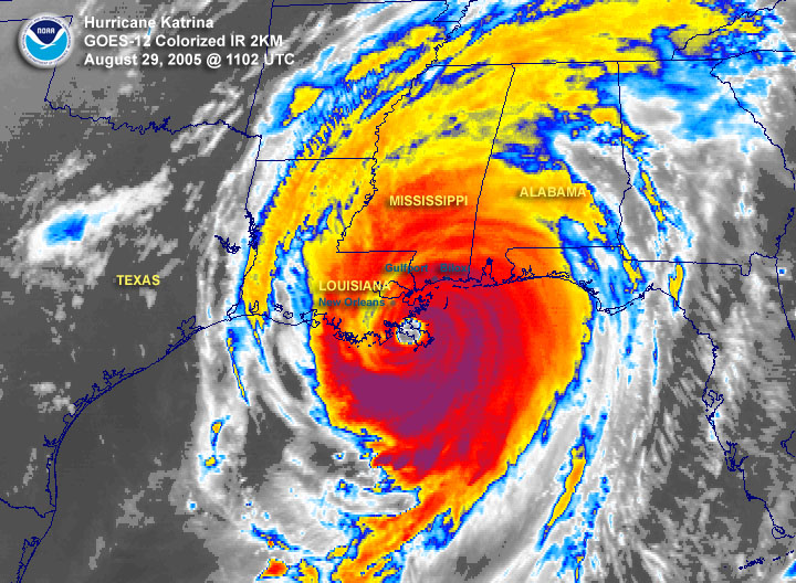
Overnight Katrina continued to slowly weaken as she approached the coast giving residents a false sense of hope. Katrina was still a strong category 4 storm. The winds were reported to be 155 mph @ 2AM, 150 mph @ 4AM, and 145 mph @ 6AM at the time of landfall midway between Grand Isle, Louisiana and the mouth of the Mississippi River in Plaquemines Parish. It was now evident the eye of the storm would pass just to the east of New Orleans. Some news media was reporting that the city would "dodge another bullet." Unfortunately, their lack of knowledge of hurricanes failed to take into account the western side of the storm would bring strong northerly winds across Lake Ponchartrain driving wind and waves into New Orleans. The warnings of a doomsday scenario from scientists from years past were about to become a reality.
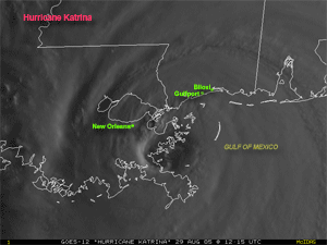
Katrina continued to move north across Plaquemines Parish emerging over the water only to strike St. Bernard Parish. Katrina, who had now been compared to Camille was about to make her final landfall along that same portion of the Mississippi coast that Camille had ravished 36 years ago. Bay St. Louis and Pass Christian were about to be demolished. Biloxi and Gulfport were not to be spared either. In fact, Katrina's powerful eastern side would stretch well into the Florida panhandle.
Massive wind damage occurred along and well to the east of the center. At 8AM Pascagoula, Mississippi was reporting wind gusts to 118 mph, Gulfport reported sustained winds of 94 mph with gusts to 100, Belle Chase, Louisiana reported sustained winds of 76 mph with gusts to 105. New Orleans - Lakefront reported sustained winds of 69 mph gusting to 86.
At 10AM, Katrina made her final landfall along the Louisiana/Mississippi border. The same spot where Camille made landfall. Many communities and towns were wiped away. The Slidell, Louisiana National Weather Service Office was obliterated. Mississippi lost power to most of the state. Well before landfall while Katrina was in the gulf, weather buoys were being picked off one-by-one by waves in excess of 30 feet. The trend continued well inland. One-by-one radars went offline.
For New Orleans, the tragedy was now unfolding. Surging waters from Lake Ponchartrain were now surging through the city after levees began to break. The city was flooded. Although the death toll will likely not be know for some time, some estimates place it in the thousands.
As is the norm, Katrina began to weaken over land while moving through Mississippi. The last advisory as a hurricane was at 4PM, Monday, August 29 while the storm was 30 miles northwest of Laurel, Mississippi. Winds gusted to 110 mph at Laurel at 2PM prior to instrument failure. By 10PM, Katrina, now a tropical storm with winds of 60 mph, was near Columbus, Mississippi. Katrina was finally downgraded to a tropical storm by 10AM Tuesday, August 30, 25 miles south of Clarksville, Tennessee.
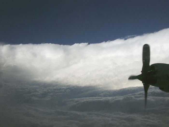
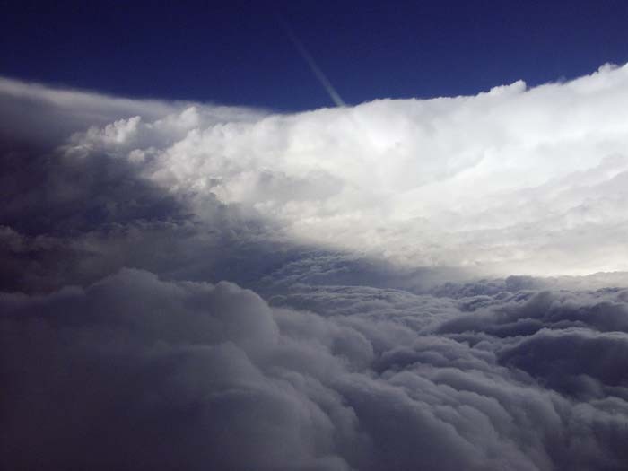
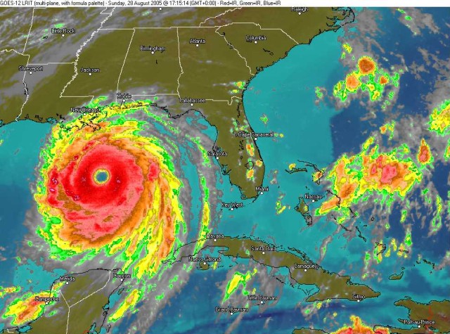
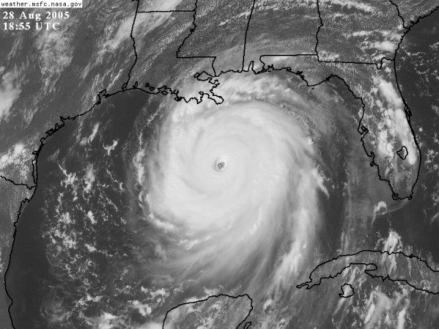
Below are images associated with Katrina. Images will likely be added as they become available.
*Later analysis from the Tropical Prediction Center/National Hurricane Center determined that Katrina had weakened to Category 3 status upon landfall along the southeast Louisiana coast with winds of 125 mph.
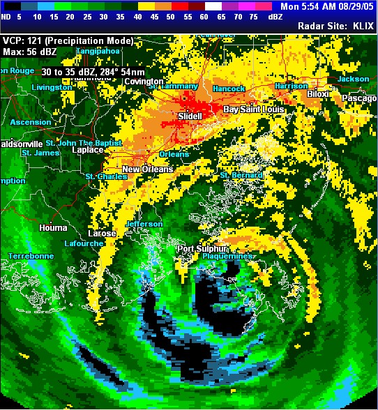
Katrina making landfall over Plaquemines Parish. Image is from Slidell, Louisiana radar.
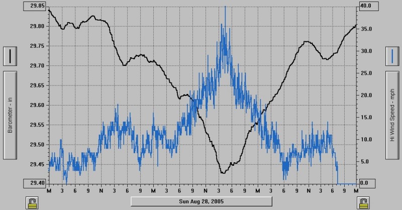
Barometer and wind trace as recorded from Monroe, Louisiana. The peak gust recorded at the airport was 41 mph. The gust shown here recorded by Delta Community College was 40 mph. The barometer dropped to 29.42".