
Super Hurricane
Rita
|
Super Hurricane
Rita |
|
BULLETIN
TROPICAL DEPRESSION EIGHTEEN ADVISORY NUMBER 1
NWS TPC/NATIONAL HURRICANE CENTER MIAMI FL
11 PM EDT SAT SEP 17 2005
...THE EIGHTEENTH TROPICAL DEPRESSION OF THE YEAR FORMS TO THE EAST
OF THE TURKS AND CAICOS...
...WATCHES AND WARNINGS ISSUED...
The birth of the 2005 hurricane season's second category five storm began like her predecessor, Katrina, in the Bahamas 95 miles ENE of Grand Turk Island. Winds at the time were only 30 mph and minimum pressure a mere 1009mb/29.80" of mercury - a far cry from what was about to happen.
Models were already predicting Rita to become a very healthy hurricane and pose a threat to south Florida. While still a depression Sunday morning, Sept. 18, a hurricane watch was issued for the Florida Keys in anticipation Rita would strengthen. She did not disappoint. Rita gained tropical storm status at 5PM that afternoon 355 miles ESE of Nassau, Bahamas. Six hours later at 11PM, the Tropical Prediction Center upgraded the hurricane watches to warnings for the Keys.
Rita spent the next 36 hours gathering forces and slowly strengthening while moving through the Bahama Islands toward extreme south Florida. She became the 9th hurricane of the 2005 season at 11AM, Tuesday, Sept. 20, 120 miles SE of Key West, Florida while moving west at 15 mph. Once the strengthening process began, the momentum only grew. Rita's pressure began to bomb.
As Rita passed south of Key West, winds increased to 100 mph lashing the lower and middle keys with hurricane force gusts during the evening hours of Sept. 20. Prior to midnight, Rita approached major hurricane status with winds of 110 mph.
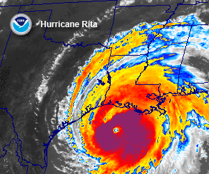
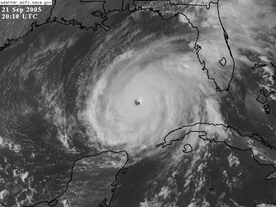
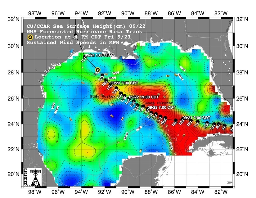
Reaching winds of 115 mph during the midnight hours of Wednesday, September 21, Rita became the season's 5th major hurricane with intense strengthening continued in the forecast. Just after dawn, the 8AM advisory reveals that she has rapidly increased to category 4 with 135 mph winds. The center was now 195 miles west of Key West in the warm southeastern gulf. Rita's pressure had dropped to 948mb/28.00" of mercury and was continuing to fall rapidly.
Models continued to indicate Rita would likely reach category 5 status in the very warm waters of the central gulf. By 4PM Wednesday afternoon, Rita did indeed reach category 5 status - the second of the season. Hurricane watches were issued for the gulf coast from Port Mansfield, Texas to Cameron, Louisiana. Winds had increased to 165 mph and the pressure plummeted to 914mb/26.99". That was not enough. Just three hours later, Rita's pressure was 898mb/26.55" giving Rita the distinction of having the 3rd lowest pressure ever recorded in Atlantic hurricane history behind Gilbert (1988) and the 1935 Labor Day Florida Keys Hurricane.
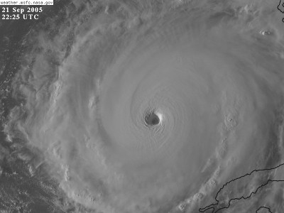
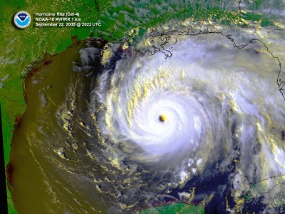
Rita broke her own record late Wednesday night. The 10PM advisory indicated her pressure continued to drop and winds continued to increase. The barometer read 897mb/26.49". Winds had increased to an incredible 175 mph - equaling Super Hurricane Katrina. At 1AM, Thursday, Sept. 22, hurricane watches were extended eastward to Intracoastal City, Louisiana in response to persistent model indications that Rita would move more to the right of the previous forecast path.
Rita maxed out during the midnight hours of Sept. 22. Her lowest pressure of 897mb/26.49" was recorded and winds peaked at 175 mph with higher gusts. Category 5 hurricanes, especially intense ones, generally do not maintain their extreme status for an extended period of time. By dawn, Rita began her slow weakening trend as forecast by computer models. Rita was now 490 miles SE of Galveston at 7AM and moving to the northwest at around 12 mph. Models were slowly becoming more consistent showing a landfall just west of Galveston to southwest Louisiana.
Hurricane warnings were issued at 10AM, Thursday, Sept. 22 from Port O'Connor, Texas to Morgan City, Louisiana. Tropical storm warnings extended east to the mouth of the Mississippi River. Rita was forecast to continue moving toward the upper Texas/southwest Louisiana coast as either a category 3 or 4 storm. Rita lost category 5 status at 1PM as winds dropped to 150 mph.
 The strong high pressure over the southern United
States slowly migrated to the east allowing Rita to turn to the northwest, then
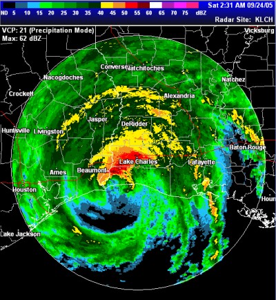
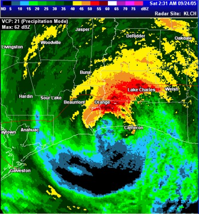
north-northwest during the night Friday. Rita made landfall as a category
3 storm with 120 mph winds over extreme southwest Louisiana (Cameron Parish) at
2:30 AM CDT, Saturday, September 24. The storm was enormous spreading
tropical storm force winds 200 miles from the center. The cities of Port
Arthur and Beaumont, Texas and Lake Charles, Louisiana took Rita's full force.
The strong high pressure over the southern United
States slowly migrated to the east allowing Rita to turn to the northwest, then
north-northwest during the night Friday. Rita made landfall as a category
3 storm with 120 mph winds over extreme southwest Louisiana (Cameron Parish) at
2:30 AM CDT, Saturday, September 24. The storm was enormous spreading
tropical storm force winds 200 miles from the center. The cities of Port
Arthur and Beaumont, Texas and Lake Charles, Louisiana took Rita's full force.
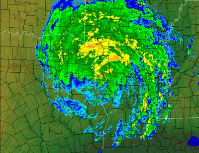
The storm moved steadily along the Texas/Louisiana border at 12 mph during the day Saturday producing heavy rain and very gusty winds along and well east of its path. Most all of Louisiana experienced tropical storm force winds in gusts. Gusts over 40 mph were common with isolated gusts to over 60 mph causing widespread tree and power line damage across the state.
Fortunately, Rita did not stall over northeast Texas as predicted preventing potentially catastrophic flooding across the region. However, Rita did provide beneficial rainfall over a drought stricken region. Tornadoes were spawned from Rita, especially over central Mississippi and central Arkansas. At least one fatality was reported in Mississippi due to a Rita spawned tornado.
Below are photographs and charts associated with Rita.
![]()
 |
 |
 |
 |
 |
 |
 |
 |
 |
 |
 |
 |
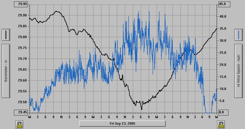
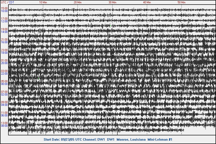
Hurricane Rita created seismic waves as she approached the coast. This image is from Delta Community College's Seismograph.
Strongest Typhoons/Hurricanes on Record by Pressure
|
Name |
Basin |
Year |
Wind MPH |
Pressure MB |
|
Typhoon Tip |
Pacific |
1979 |
190 |
870 |
|
Typhoon Zeb |
Pacific |
1998 |
--- |
872 |
|
Typhoon Gay |
Pacific |
1992 |
185 |
872 |
|
Typhoon Keith |
Pacific |
1997 |
190 |
872 |
|
Typhoon Joan |
Pacific |
1997 |
--- |
872 |
|
Typhoon Ivan |
Pacific |
1997 |
--- |
872 |
|
Typhoon Yuri |
Pacific |
1991 |
175 |
885 |
|
Hurricane Gilbert |
Atlantic |
1988 |
185 |
888 |
|
Typhoon Nancy |
Pacific |
1961 |
213 (debated) |
888 |
|
Labor Day Hurricane |
Atlantic |
1935 |
160 |
892 |
|
Hurricane Rita |
Atlantic |
2005 |
175 |
897 |
|
Hurricane Allen |
Atlantic |
1980 |
190 |
899 |
|
Hurricane Linda |
Pacific |
1997 |
185 |
900 |
|
Hurricane Katrina |
Atlantic |
2005 |
175 |
902 |
|
Hurricane Camille |
Atlantic |
1969 |
190 |
905 |
|
Hurricane Mitch |
Atlantic |
1998 |
180 |
906 |