1998 North Louisiana Christmas Ice Storm
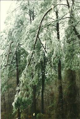
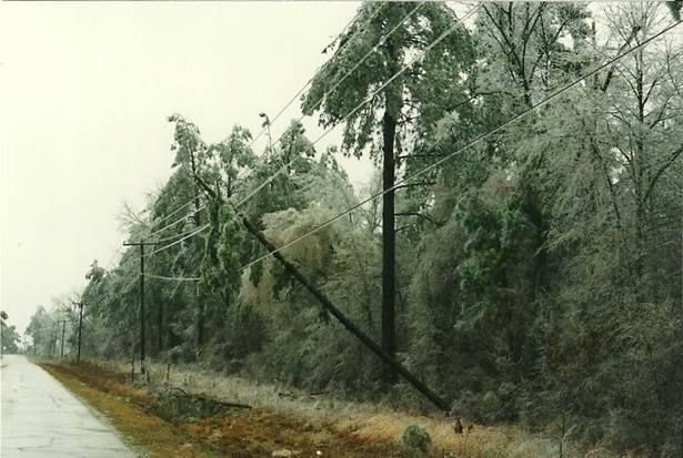
As we approach the Christmas holiday season, it's time to prepare for winter weather events here in the deep south. While we usually do not experience the blizzard conditions Snowfall events, while somewhat rare, are usually a welcome sight to our area. They usually give the kids and kids at heart an "extra" day off to play in the snow. Snow does little or no damage to man-made structures and trees, and usually melts away in a day or two. Ice storms, i.e. freezing rain, sleet, and snow, do cause more than just a little inconvenience. Damage to structures and trees can be significant and costly. North Louisiana has experienced some memorable ice storms over the years. This was the case on the Christmas of 1998 (Kringle Ice Storm). Not only was it a destructive storm with power outages, it occurred over the Christmas Holidays when families were gathering and celebrating. This was the first storm Don Wheeler and Tom Malmay worked on together. It was also one of the first storms where the internet was used to leverage federal assistance. Duffy Frantom and many others worked in the EOC. Years later Tom penned a poem about the 1998 Ice Storm.
Ice, with its destructive weight, causes considerable damage to trees, power lines, and man-made structures. It also creates very dangerous driving conditions which result in accidents and injury. Typically, ice storms last two to three days but its affects can be long lasting. Electrical power is usually affected the most during an ice event, sometimes taking as much as two weeks or longer for restoration. Winter Weather Advisory Winter Storm Watch Winter Storm Warning *Winter Storm Criteria
Ice Events
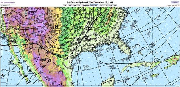
North Louisiana Ice Storm – December, 1998 December is a month of transition for north Louisiana as the autumn season wanes into winter. Air masses often clash allowing for large swings in temperature and a variety of weather phenomena. December, 1998 was no exception. The month began rather warm with highs across north Louisiana topping out in the lower 80s the first week of the month, some twenty degrees above normal for that time of year. A cold front the second week of December would bring temperatures down to below normal readings due to persistent cloud cover and rain the second week. Highs that week were in the mid and upper 40s, ten to fifteen degrees below normal. By the end of the second week, temperatures were on the rebound with a slow warming trend. Highs between the 16th and 20th rose into the 60s as winds veered to a southeasterly direction. Big changes were on the horizon. A strong Arctic air mass, with a 1045mb high over the northern Rockies at its heart and a secondary 1039mb high over southwest Kansas, was poised to rapidly spread southward. Temperatures ahead of the front rose into the mid 70s on the 21st across north Louisiana. At 00Z on December 22 (6PM CST on the 21st), the front began to sweep into north Louisiana. As of the 00Z observation, Monroe reported 72 degrees while just across the Louisiana border in northeast Texas, temperatures had already dropped into the upper 20s and lower 30s.
The front would continue southeastward into the northern gulf where it would become stationary setting up a classic overrunning situation where warm moist air flows northward over the shallow Arctic air mass. With this air mass, the air was cold enough to allow for frozen precipitation across north Louisiana – in this case sleet and freezing rain.
The type of precipitation that falls during a winter weather event is largely dependent upon the vertical structure of the lower atmosphere with regard to temperature. Often Arctic air masses that penetrate into Louisiana are rather shallow with the denser cold air being close to the surface. In the diagram above, south is to the left of the image and north is to the right looking from east toward the west.
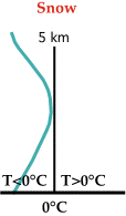
In the first diagram, the deepest cold air is furthest north which will allow the entire vertical column of air to be at or below freezing. Thus, snow would be the primary type of precipitation to fall in this area. The diagram to the left shows the vertical temperature (green line) in relation to the 0C/32F line. Note the entire temperature profile is at or below 0C/32F.
As we move further south, the cold air at the surface becomes shallower with a thin layer of warm air above it. This will allow any snow that forms in the cloud layer to melt, then refreeze into ice pellets/sleet before making it to the surface. In the accompanying diagram to the right, note the temperature (green line) briefly rises above freezing just long enough to melt the snow but enough distance is available to allow the liquid precipitation to refreeze before reaching the surface.
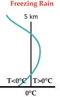
Continuing further south, the cold air becomes even more shallow which does not give any liquid precipitation time to refreeze before it reaches the ground. However, the air and objects near the surface are at or below freezing allowing the liquid precipitation to freeze on or shortly after contact with surfaces. Note on the diagram at the left the green temperature line extends further into the area above the freezing line than with the sleet diagram above.
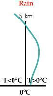
Finally, we reach a point furthest south where the entire lower column of air is above the freezing point; therefore, only liquid precipitation falls in this zone.
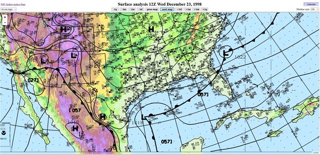
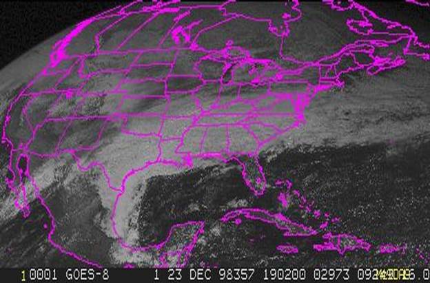
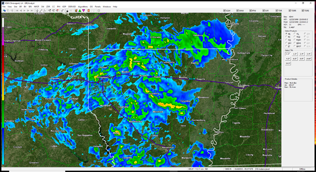
The surface map and satellite imagery show the frontal position across the northern gulf with the area of low pressure in the northwest gulf. Radar imagery from the National Weather Service in Shreveport on the afternoon of December 23 shows widespread rainfall (freezing rain) with some areas of sleet across much of north Louisiana. Due to the low-level height of the precipitation, some was not detected along the outer edges of the radar’s usual coverage area.
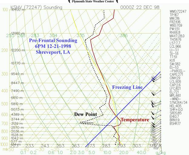
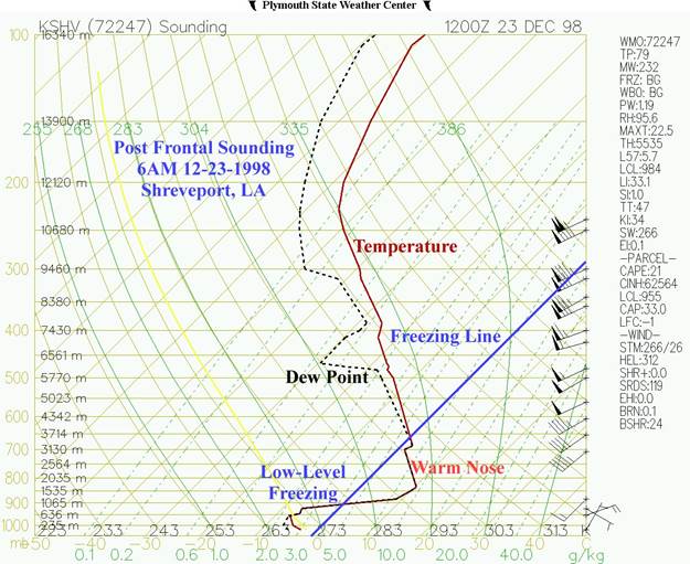
Skew-T diagrams/soundings from the National Weather Service in Shreveport displayed a classic Freezing Rain/Sleet event. The first diagram is pre-frontal taken at 6PM, December 21 (00Z, December 22). The diagonal blue line is the freezing line (0 C), the red line is the temperature, and the dashed black line is the dew point. Temperatures to the left of the blue freezing line are below freezing and above freezing to the right of the line. Note the warm surface temperature ahead of the front in the lower 70s (about 22 C). Thirty-six hours later at 6AM, December 23 (12Z, December 23), the shallow cold Arctic air extending up only to about 1000 meters (3281 feet) above the surface. From 1000 meters to just under 3700 meters (12,139 feet) the temperature was above the freezing line. Also note the saturated air from near the surface to about 3700 meters. In fact, the temperature at 5200 feet was a “warm” 50 degrees (10 C).
Liquid equivalent totals during the freezing component of the event ranged from near one-half inch to one-and-a-half inches. These amounts led to significant ice accumulations on all exposed objects resulting in extensive tree and powerline damage. Ice (freezing rain and sleet) accumulations on the ground also ranged upward to over an inch in many locations across north Louisiana.
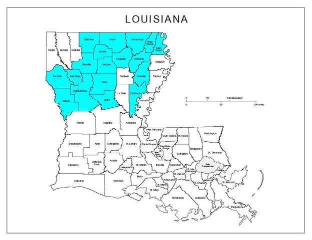
According to the Federal Emergency Management Agency (FEMA), 17 parishes were granted “Public Assistance” (assistance to state, local, tribal and territorial governments and certain private-non-profit organizations for emergency work and the repair or replacement of disaster-damaged facilities) due to the winter storm. The incident period was from December 22, 1998 – December 28, 1998 and was declared on January 21, 1999.
Sources |

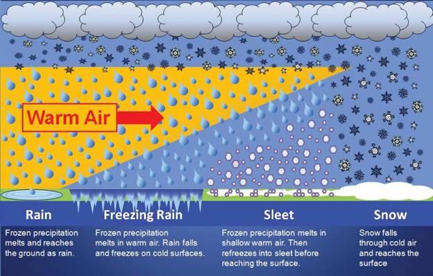
 The following diagrams will illustrate the basic conditions needed for each type of precipitation that could be associated with a winter weather event: snow, sleet, freezing rain, and rain.
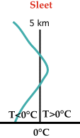
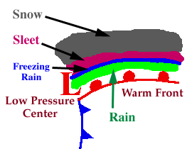 As the cold front continued south into the gulf and became stationary, an area of low pressure developed along the front in the northwest gulf providing a setup similar to the diagram at the left. North Louisiana found itself within the freezing rain and sleet zone. Rain transitioned over to a mix of freezing rain and sleet during the overnight hours of the 21st and morning hours of the 22nd. Temperatures during the day on the 22nd briefly rose above the freezing mark, topping out at 33 at the Monroe Airport, 34 at Sterlington, and 34 at the Calhoun Research Station – all in Ouachita Parish. Surrounding parishes had similar readings. The temperature quickly fell below freezing as the cold Arctic air funneled into the region. It stayed at or below freezing at most north Louisiana locations until the 25th and then only briefly above freezing during the day.