
Become a Louisiana CoCoRaHS Observer! Click HERE for details.


Forecasts & Models
Local NWS Forecast Discussions
NWS-Shreveport
NWS-Jackson
NWS-Lake Charles
NWS-New Orleans
Forecast and Model Tools
Conditions, Discussions, Forecasts
Bayou State Models Page
College of DuPage
PivotalWeather (with EURO Model)
Weather.US (with EURO Model)
Tropical Tidbits (with EURO Model)
Weather Nerds Models
Twister Data (Models)
Penn State
NWS MOS Forecast Models
NWS MAV/MOS Forecast Models KMLU
UCAR Models
NCEP Models
Hydrometeorological Prediction Center
Snowfall Forecasts
Winter Weather Forecast - NWS-Shreveport
Winter Weather Forecast - NWS-Jackson
Forecast Maps
Skew Ts/Hodographs/Stuve
Forecast Skew Ts/Hodographs
Tropical Spaghetti Models
Weather Nerds Tropical Ensembles
Severe Weather Information
Airport/Current Weather
Current/Past Conditions at Alexandria
Current/Past Conditions at Baton Rouge
Current/Past Conditions at Lafayette
Current/Past Conditions at Lake Charles
Current/Past Conditions at Monroe
Current/Past Conditions at New Orleans
Current/Past Conditions at Shreveport
Louisiana Mesonet (ULM)
Climate
Alexandria, Lake Charles & Lafayette Climate Data/Records
Monroe & Shreveport Climate Data/Records
Baton Rouge & New Orleans Climate Data/Records
Southern Region Climate
US Climate Data
US State by State Climate Records/Extremes
Archived NWS Text Products
Louisiana Water Levels
At-A-Glance
North Louisiana
South Louisiana
USGS Water Level Information
River Gauges.com
US Army Corp of Engineers
Air Quality
Bayou State
AirNow.gov
Environmental Protection Agency - EPA
IQ Air (global)
Louisiana Dept. of Environmental Quality
Purple Air
Drought Monitor
Louisiana Drought Map
Louisiana Fire Hazard/Burn Bans
NOAA Weather Radio

noaaweatherradio.org
Monroe, LA (noaaweatherradio.org)
Monroe, LA (broadcastify.com)
Monroe, LA (weatherusa.net)
Shreveport, LA (noaaweatherradio.org) Shreveport, LA (broadcastify.com)
Shreveport, LA (weatherusa.net)
Baton Rouge, LA (noaaweatherradio.org)
Tyler, TX (noaaweatherradio.org)
Tyler, TX (broadcastify.com)
Radar

Bayou State Radar Page
Lightning
Bayou State Lightning Detection System
Blitzortung Lightning Detection
Lightning Maps
Windy.com
Satellite Imagery

Bayou State Satellite Page
LSU Earth Scan
GHCC Satellite
UCAR/NOAA/NESDIS
Archived Satellite
RAMSDIS/Colorado State Satellite
NOAA Server
Seasons
Spaceweather
Weather Maps
Bayou State Surface Map Page
Bayou State Forecast Map Page
Bayou State Upper Map Page
Hydrometeorological Prediction
MOS Forecast Models
Penn State Models
NCEP Models
UCAR Models Page
UCAR Maps Page
Stuve Diagram/Hodographs
Forecast Skew T's/Hodographs
Severe Weather
Chaser Page
Storm Prediction Center
Storm Damage Viewer (NWS)
NOAA Weather Hazards Viewer
Fujita Scale
Severe Weather Tips
SKYWARN
Storm Chase.net
Stormgasm.com
Storm Track Online
TESSA
The Tornado Project
Twister Data
Bayou State Tornado Archives
Louisiana Severe Weather & Storm Reports
Live Chase Cam Networks
Severe Studios
LiveStormChase.com

Idaho Storm Chaser.com
Mike Ridgeway
Storm Chaser/Educator
Winter Weather
Winter Weather Tips
Winter Weather Forecast - NWS-Shreveport
Winter Weather Forecast - NWS-Jackson
Ice Storm 1994
New Year's Snow 2000
February Snow 2010
Ice Storm 2013
Tropical Weather
Tropics (Bayou State Weather)
Tropical Prediction Center
Florida State Tropical Models
Spaghetti Models
Hurricane Watch Net
Hurricane Alley Net
Hurricane City.com
Sea Surface Temperatures
US Navy Worldwide Tropical Page
Weather Underground
River Stages/Ag Reports
Rainfall Reports - Shreveport WSO
Rainfall Reports - Lake Charles WSO
Rainfall Reports - New Orleans WSO
Current Louisiana River Stages
Seismology/Earthquakes

Seismology/Earthquakes
N.O.A.A.
National Weather Service

NWS Offices
NWS-Shreveport, LA
NWS-Lake Charles, LA
NWS-Slidell/New Orleans, LA
NWS-Jackson, MS
NWS-Little Rock, AR
NWS-Southern Reg. Headquarters
Universities and Colleges

University of Louisiana-Monroe

LSU-Louisiana Agriclimate
La. Office of State Climatology/LSU
University of Wyoming
College of Dupage
University of South Alabama
Florida State
University of Wisconsin
University of Oklahoma
Texas A&M
Texas Tech
Mississippi State
Plymouth State University
Penn State
Jackson State
University of Hawaii
Miscellaneous Weather
The Weather Channel
Tornado Project
AccuWeather
Unisys
UCAR
Mt. Washington Observatory
Farmer's Almanac
Drought Monitor
Crown Weather

American Meteorological Society
DataStreme Project
National Weather Association


Disclaimer
While this web site, Bayou State Weather LLC, attempts to bring you the very latest in weather information, it is subject to the availability and realiability of the internet and the functionality of the computers running the many software programs which generate weather information. The information on the pages should always be checked for accuracy and should NEVER be used for the protection of life and/or property. |
Local Forecast for Shreveport, Louisiana and Caddo Parish
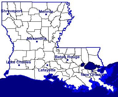
Louisiana River, Lake, and Bayou Stages
North Louisiana River and Select Lake Stages
South Louisiana River and Select Lake Stages

Forecasts
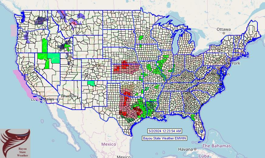
(click on the map below for National Weather Service zone forecasts from Bayou State Weather EMWIN) |
|
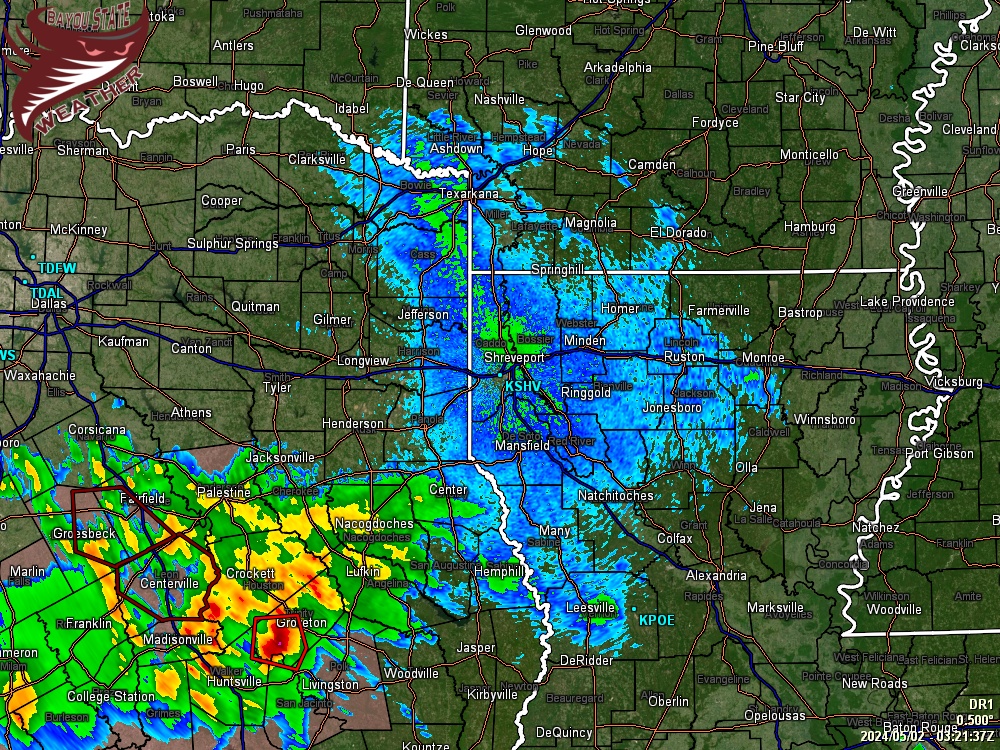
Current Radar
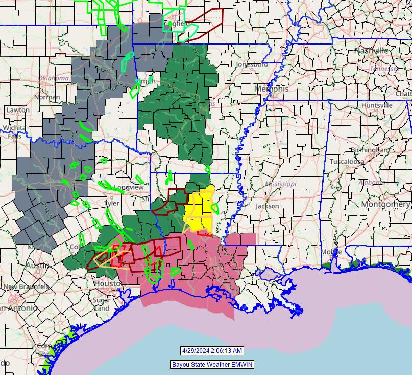
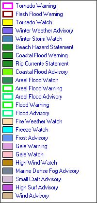
Latest Watch, Warning, and Advisories from Bayou State Weather EMWIN
(click on the map below for current watches, warnings, and advisories)
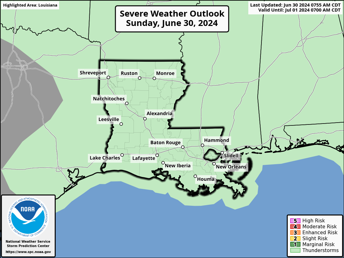
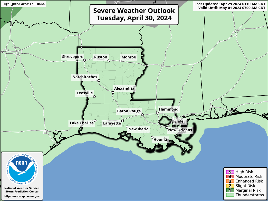
Severe Weather Outlooks
Lightning Detection, Surface Map, Air Quality and Satellite Imagery
Lightning Map Courtesy of Blitzortung Lightning Detection Network
NOTE: The map below has several settings for your viewing pleasure. Click the  icon in the upper right of the map for settings. Click HERE for suggested settings. icon in the upper right of the map for settings. Click HERE for suggested settings.
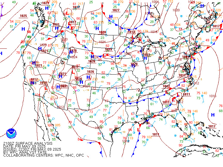
Surface Map
Louisiana Air Quality
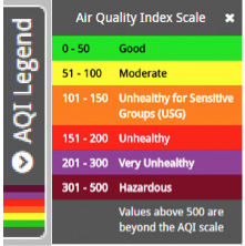 |
The map below depicts air quality across Louisiana. It represents a measure of airborne particulate matter (PM). Particulate matter describes solid particles suspended in air including dust, smoke, and other organic and inorganic particles. PurpleAir sensors use laser particle counters to count the number of particles by particle sizes 0.3, 0.5, 1, 2.5, 5, and 10 μm, and uses the count data to calculate mass concentrations of PM1.0, PM2.5, and PM10. This map does not include Ozone which is also dangerous in high quantities. Use your mouse wheel or the "+/-" icons to zoom in or out. Click on a station below to see detailed information/data. |
Map and Data Courtesy of PurpleAir.com

|

